Document 4: NYPL Map of Hunts Point
So far, your investigation of the documents has uncovered some interesting information about Hunts Point. But, where at in Hunts Point?
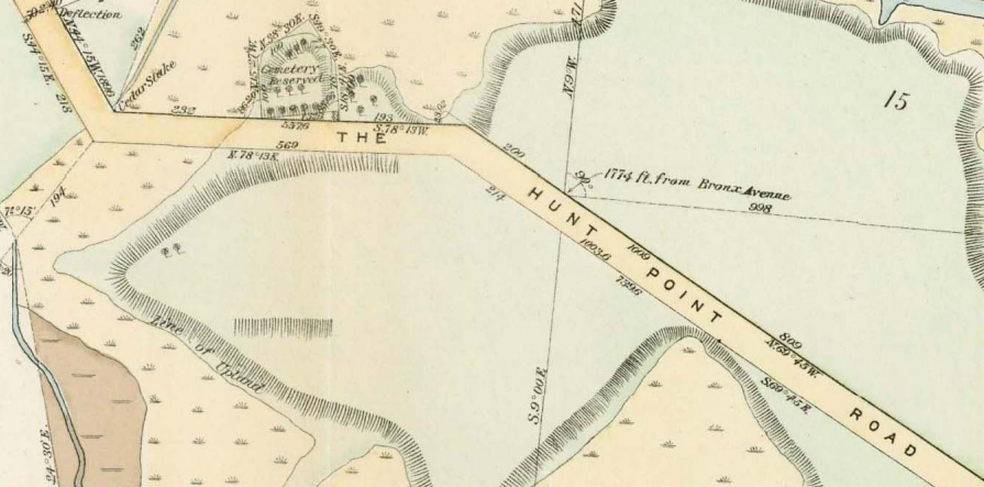
Maps can help you understand a place. They can help you locate buildings, streets, and cemeteries (burying grounds) built by humans. They also can show you natural places, such as rivers, marshland, and hills. This is called geography. Last, maps can help you see how a place changes over time. Investigate this map of Hunts Point from over 125 years ago. Learn about how Hunts Point has changed and clues for your investigation.
Maps can help you understand a place. They can help you locate buildings, streets, and cemeteries (burying grounds) built by humans. They also can show you natural places, such as rivers, marshland, and hills. This is called geography. Last, maps can help you see how a place changes over time. Investigate this map of Hunts Point from over 125 years ago. Learn about how Hunts Point has changed and clues for your investigation.
Complete Map
Look closely all over the map of Hunts Point. Think about these questions, and more! Complete the parts of your research journal as you analyze this document.
- What year was this map created? TIP: Look at the bottom right side of the map!
- What names do you recognize on the map? What do they stand for?
- What colors does the map use? What do the colors stand for?

Document Source: NYPL Digital Gallery. Atlases of New York city. / Certified copies of important maps appertaining to the 23rd and 24th wards, City of New York, filed in the Register's office at White Plains, County of Westchester, New York.
Map zoom
- Find the cemetery located on the map. What road is this cemetery on?
- Where would “directly opposite the Hunt burying ground” be located? TIP: Where did you read those words before?
- How does this map remind you of information you have already learned?
Document Source: NYPL Digital Gallery. Atlases of New York city. / Certified copies of important maps appertaining to the 23rd and 24th wards, City of New York, filed in the Register's office at White Plains, County of Westchester, New York.
