Hunts Point Slave Burial Ground
  • Home
  • About The Project
  • Moving Towards Permanent Remembrance
  • Location
  • Upcoming and Recent HPSBG Events
  • Media
    • The New York Times November 2017
    • The Sonnet Project
    • Hunts Point Express June 2016
    • The New York Times January 2014
    • The Periwinkle Initiative
    • ABC7 Here and Now
    • Hunts Point Fish Parade 2014
    • Remember the Forgotten
    • May 2014 Press Conference
    • The Daffodil Project
    • January 2014 Press Conference
    • EBHF Talk
    • Daily News Revisits HPSBG
    • BronxTalk Coverage
    • The Burial Ground: A Short Film by Monique John
    • HPSBG Trailer
    • Daily News Coverage
    • HPSBG Presentation
  • Project Partners
  • Historians at Work
  • Curriculum
    • Project Flow and Teaching Ideas
    • Common Core Learning Standards
    • Lesson Plan Format
    • Classroom Science Resources
    • Social Studies and Literacy Resources
  • Learning Center
  • Census Data
  • Slavery and the Burial Ground
  • Drake Park Today
  • History of Drake Park
  • P.S. 48 and The Park
  • Hunts Point Maps
  • Hunts Point History
  • HPSBG Facebook
  • Contact HPSBG
  • Donate
Transform Learning About History to Doing Something About History 
​
What will you investigate?

HUNTS POINT Maps

View historic and modern maps of Hunts Point, including the area of the Hunts Point Slave Burial Ground and PS 48, the school involved in uncovering the history of the area.  Visit the location yourself with the historic maps below in hand or on a tablet.  Experience the history all around you!
Picture
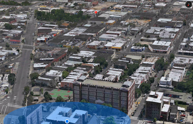
A view of P.S. 48 in the foreground and Drake Park, location of the Hunts Point Slave Burial Ground, in the background. Image: Apple Maps.
1860 Throgs Neck to the City of NY.pdf
File Size: 1268 kb
File Type: pdf
Download File

1860__throgs_neck_to_ny_zoom_1.pdf
File Size: 1568 kb
File Type: pdf
Download File

1860 Throgs Neck to the City of NY Zoom 2.pdf
File Size: 1619 kb
File Type: pdf
Download File


1873 Bronx Top Map1.pdf
File Size: 166 kb
File Type: pdf
Download File

1873 Bronx Top Map2.pdf
File Size: 97 kb
File Type: pdf
Download File

1873 Bronx Map Merged.pdf
File Size: 95 kb
File Type: pdf
Download File

1879.pdf
File Size: 6029 kb
File Type: pdf
Download File

1879 & 1893 Hunts Point Map.pdf
File Size: 588 kb
File Type: pdf
Download File

1888 Zoom in on Hunt Mansion.pdf
File Size: 82 kb
File Type: pdf
Download File

1888 NYPL Map.pdf
File Size: 153 kb
File Type: pdf
Download File

1888 NYPL Map Zoomed In.pdf
File Size: 112 kb
File Type: pdf
Download File

Rev War Era Map of the Bronx.pdf
File Size: 7560 kb
File Type: pdf
Download File

1897 Bronx Coast1.pdf
File Size: 4617 kb
File Type: pdf
Download File

1897 Bronx Coast2.pdf
File Size: 4616 kb
File Type: pdf
Download File

1897 Bronx Coast3.pdf
File Size: 146 kb
File Type: pdf
Download File

1914 BX River Condemndation Map.pdf
File Size: 2576 kb
File Type: pdf
Download File

WCS Historical Bronx River.pdf
File Size: 517 kb
File Type: pdf
Download File

North Side Board of Trade Overlay-Casey.pdf
File Size: 555 kb
File Type: pdf
Download File

1930 Bromley.pdf
File Size: 230 kb
File Type: pdf
Download File

Current Drake Park.pdf
File Size: 107 kb
File Type: pdf
Download File

Atlas 23rd Ward1.pdf
File Size: 2098 kb
File Type: pdf
Download File

Atlas 23rd Ward2.pdf
File Size: 1330 kb
File Type: pdf
Download File

Atlas 23rd Ward3.pdf
File Size: 1541 kb
File Type: pdf
Download File

Atlas 23rd Ward4.pdf
File Size: 2696 kb
File Type: pdf
Download File

Hunts Point 23rd Ward1.pdf
File Size: 78 kb
File Type: pdf
Download File

Hunts Point 23rd Ward2.pdf
File Size: 55 kb
File Type: pdf
Download File

Hunts Point 23rd Ward3.pdf
File Size: 58 kb
File Type: pdf
Download File

Hunts Point 23rd Ward4.pdf
File Size: 62 kb
File Type: pdf
Download File

Hunts Point 23rd Ward5.pdf
File Size: 68 kb
File Type: pdf
Download File

Hunts Point 23rd Ward6.pdf
File Size: 72 kb
File Type: pdf
Download File

Hunts Point 23rd Ward7.pdf
File Size: 67 kb
File Type: pdf
Download File

Hunts Point 23rd Ward8.pdf
File Size: 54 kb
File Type: pdf
Download File

1781 British Survey Country Adjacent to Kindsbridge.pdf
File Size: 674 kb
File Type: pdf
Download File

University of Michigan link to 1781 Survey 
Hunts Point Map Vol 4 Maps 1888-1897 NYPL Plate18.pdf
File Size: 996 kb
File Type: pdf
Download File

University of Michigan Archived Map 'Region Between Westchester Creek and Bronx River'
HPSBG is an educational project housed in PS 48, an NYC public school. Transform Learning About History to Doing Something About History
Donate   Contact   About   Connect on Facebook